

May 21st was the first of several chase days for this trip with my chase partner Skip Talbot. We got to Colorado and had a 10% tornado risk setup. We were incredibly excited at the prospects of chasing Colorado. I was born and raised in Arvada, CO - so it felt like coming home in a way, and was interesting and strange to be chasing so close to where I grew up.
.jpg)

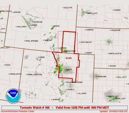
Very soon we had a tornado watch for the Denver metro area that extended north into Wyoming. Our target was northeast of the metro area in Denver, specifically looking east of Denver around the airport and east of there.
By 2pm we had a single beastly tornado warned supercell that was the clear, dominant storm.


An hour later it displayed a truly nasty looking hook on radar with a strong couplet, and it was right over the radar site. (That's the black dot you see below.)


We got to a position to view the storm but it was clearly a high precipitation style storm. Skip below, taking photos on his phone.

Falling in line with Colorado storms, this one was a beauty.


Right around this time was where there was a tornado reported on the storm. We were pretty far away from it though we were positioned to look directly into the inflow notch. The road network in Colorado is a grid, but the quality of the roads can be questionable: dirt / mud / gravel. With the dry Colorado landscape and the amounts of rain being dumped, the ground was quickly overtaken by water and made several roads impassable. A few fellow chasers ended up being stuck or stranded because of the flooding. Luckily we managed to stay ahead of the storm.


We did not see the tornado that was reported despite being in position to view it, had the storm not had such a High Precip mode. We did, however, have a gorgeous view of the overall structure of the storm.


